
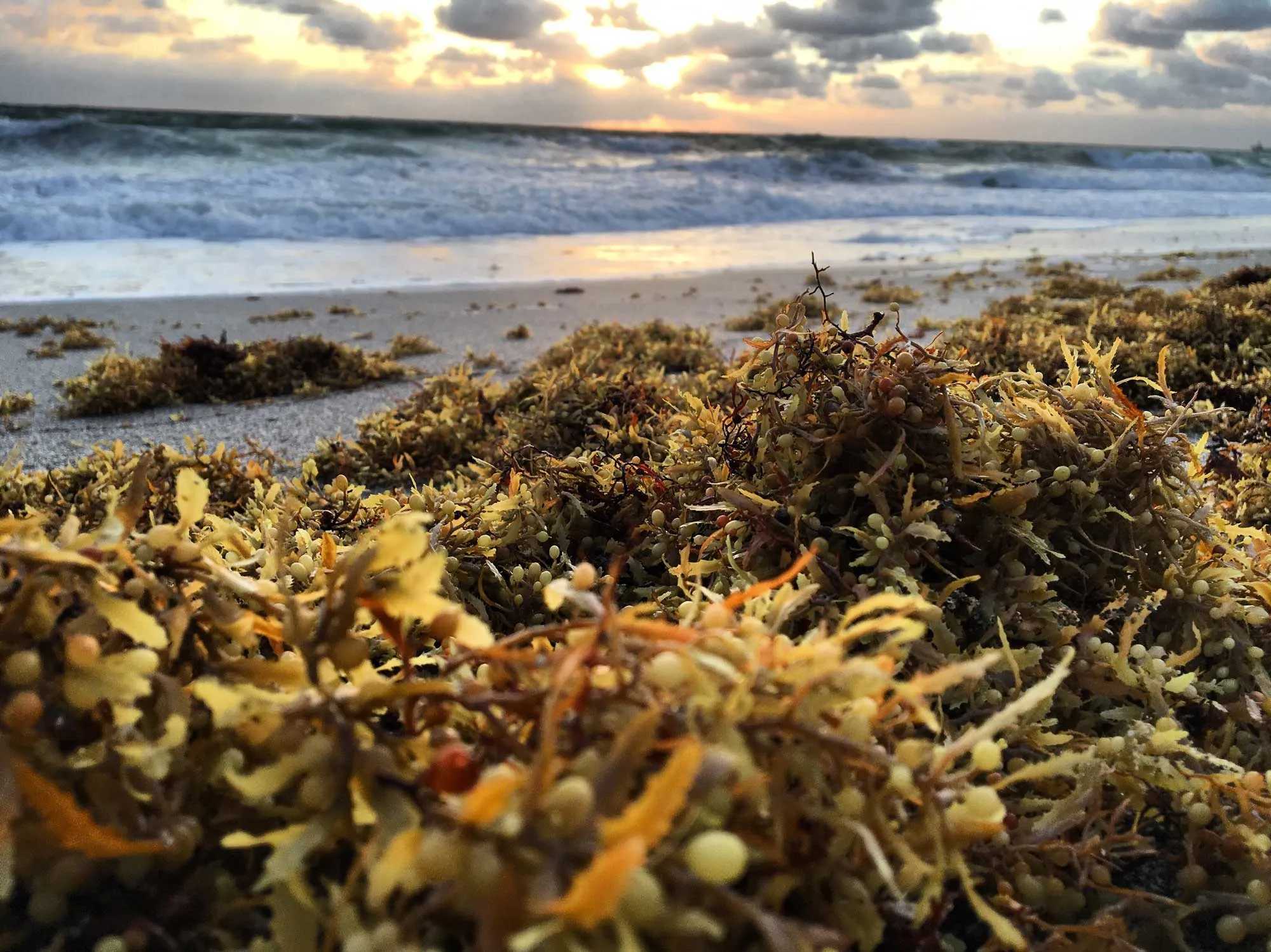
Since 2011, unprecedented massive, episodic strandings of floating holopelagic Sargassum, a genus of large brown floating algae, have been observed along the shorelines of the Gulf of Mexico, the Caribbean Sea and the tropical Atlantic.
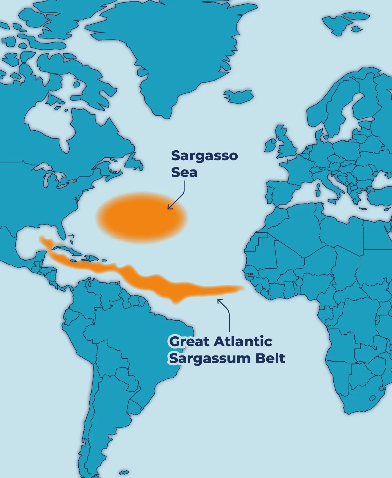
The extension of this phenomenon from West Africa to the Gulf of Mexico is known as the Great Atlantic Sargassum Belt (GASB).
The large influxes of Sargassum on beaches and in coastal areas have become a new norm, increasingly harming marine ecosystems, disrupting coastal activities, and impacting local communities.
This use case presents how the European Union is contributing to the detection, monitoring and forecasting of global Sargassum influxes, and providing free and open access to data and information needed to understand the Sargassum basin-wide spread, its impacts and inform mitigation and adaptation strategies.
Description
The Sargassum problem
Once confined to the Sargasso Sea, a recent study suggests that anomalous winds during the extreme negative phase of the winter 2009–2010 North Atlantic Oscillation (NAO) could have been a “tipping point” by transporting Sargassum from the Sargasso Sea toward the central Tropical North Atlantic, where it now proliferates and seasonally end up on beaches in the Caribbean, Americas and West Africa.
Large influxes of floating Sargassum in nearshore coastal areas and beaches can cause tremendous harm to marine life and coastal ecosystems, negatively impact public health and disrupt coastal activities, from tourism to fisheries, costing local communities millions of dollars.
Impacts of Sargassum
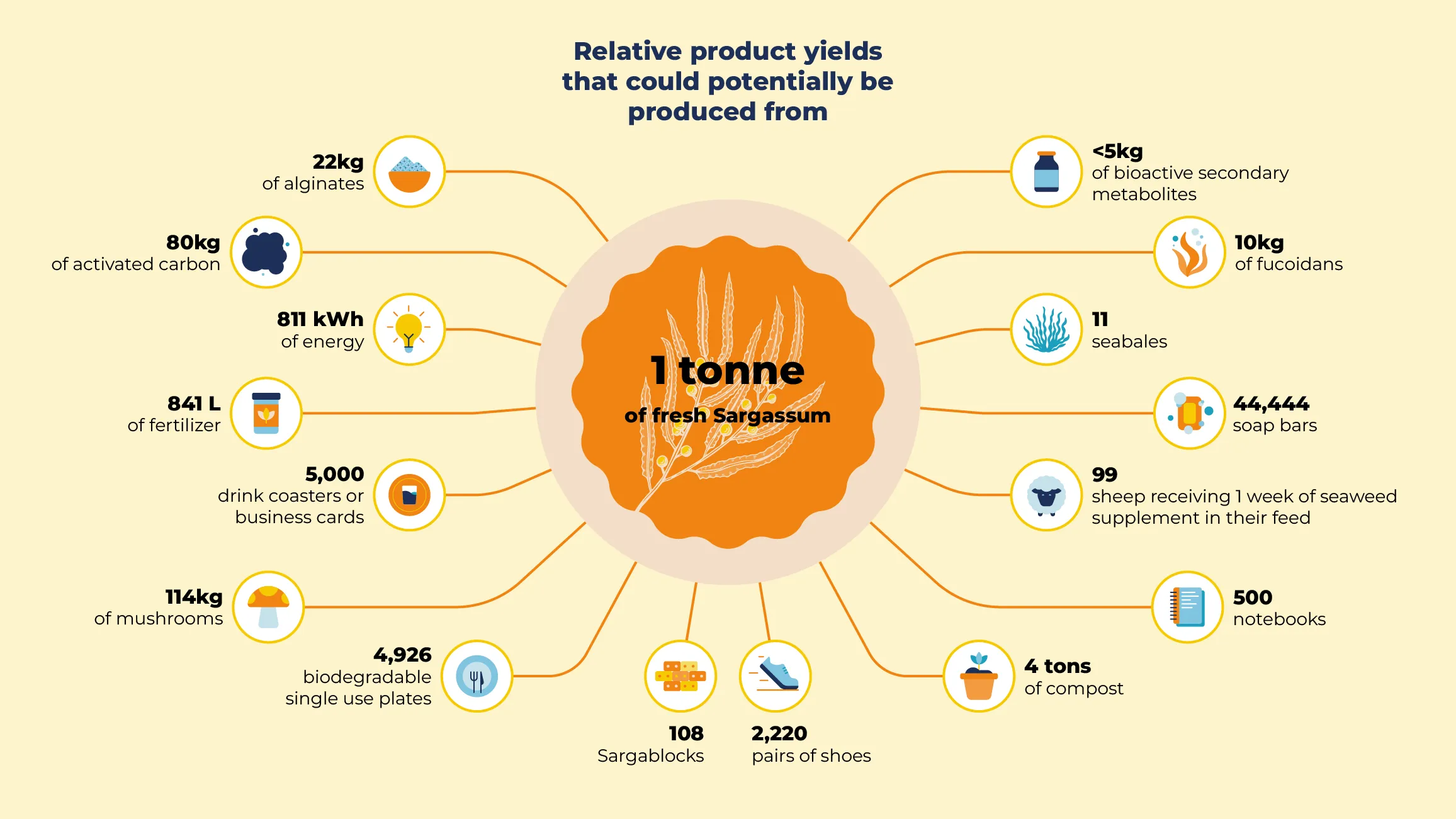
Despite these negative and harmful impacts, harvested Sargassum may also provide raw materials for commercial use and presents opportunities for economic development.
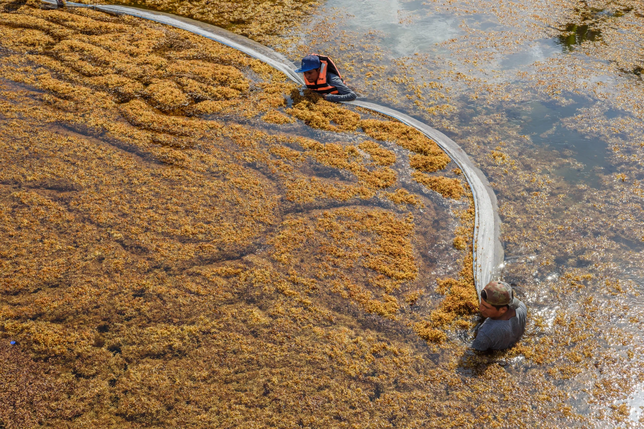
Potential uses include agriculture, bioenergy, bioplastics, construction and cosmetics among others. Sargassum can be harvested on land after it has reached the coast or at sea. Both options require sufficient manpower, costly equipment and reliable Sargassum drift forecasts to determine where to install harvesting machinery in a timely manner.
Without an effective management and exploitation strategy in place, benefits are mostly likely lost with large quantities of Sargassum repeatedly overwhelming coastal areas and are often offset by major negative impacts depending on the resources available and coastal activities.
Earth observation data to help address challenges of Sargassum inundations
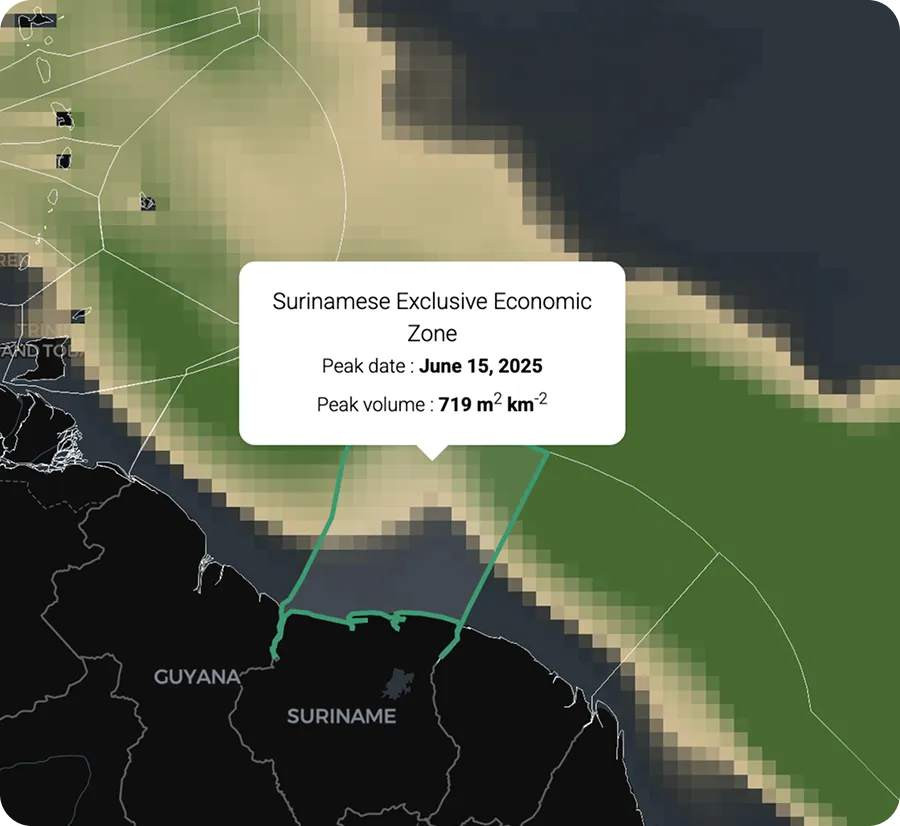
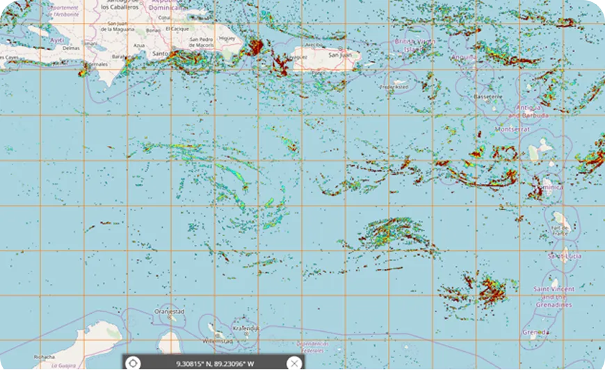
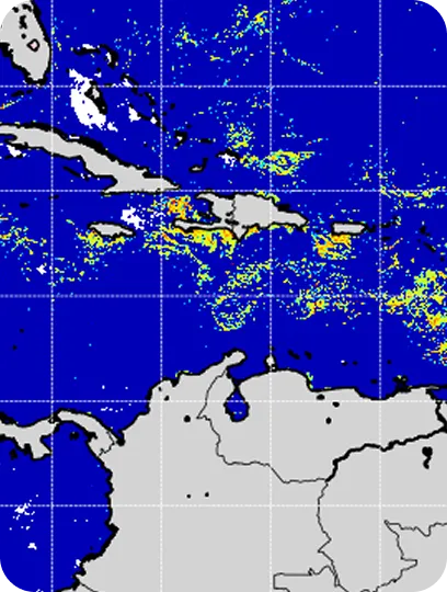
Detecting, modelling and forecasting of floating Sargassum are essential for designing effective integrated risk management, mitigation, and adaptation strategies. Thanks to the US and the European Copernicus Earth Observation programmes there has been significant progress in global remote detection of floating Sargassum. Satellite detection of floating Sargassum relies on specific algorithms, which capture wavelengths of reflected light associated with the presence of Sargassum in the signal received by the on-board sensor.
Today, the following instruments provide ocean colour products and other data products that allow detection, quantification and tracking of Sargassum mats over large regions:
Onboard the Aqua & Terra satellites
Onboard the Copernicus Sentinel-3 (A & B) satellites
Onboard the Copernicus Sentinel-2 (A & B) satellites
Onboard the GOES-16 satellite
Onboard the Landsat-8 satellite
Onboard the Suomi NPP and NOAA-20 satellite
At the same time, these observations contribute to better understanding of transport, growth, and decay properties of the mats, and provide long time series to investigate trends and variability patterns.
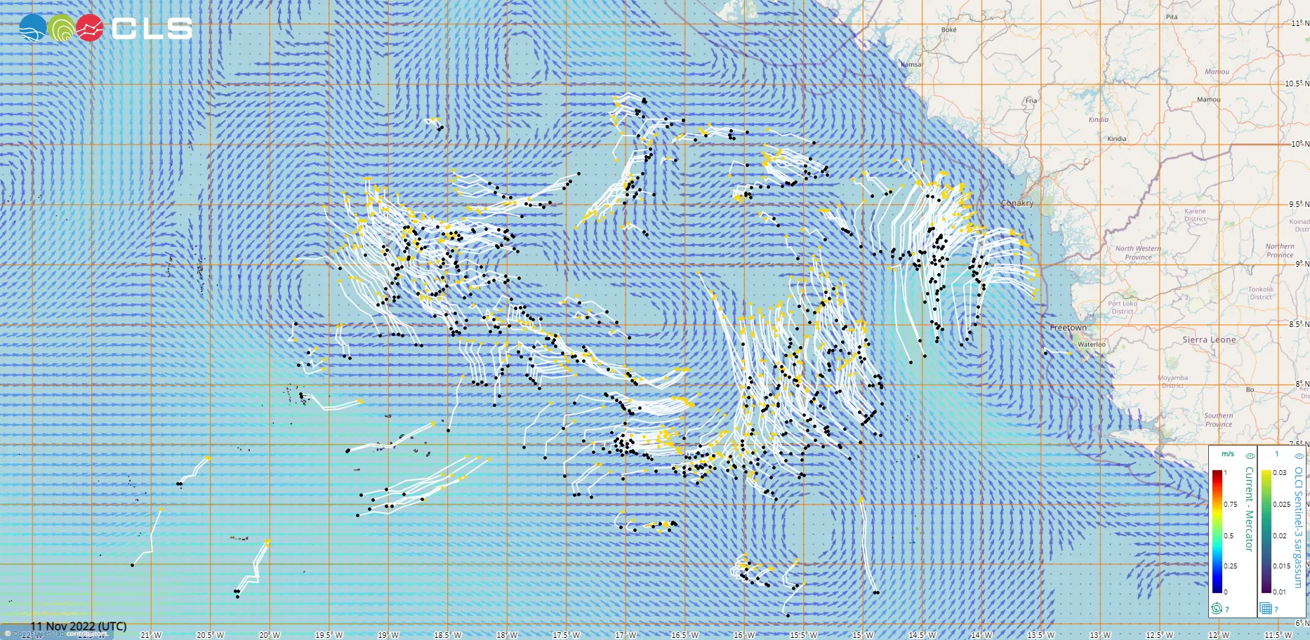
Modelling of Sargassum transport and physiology helps clarify the link between Sargassum distribution and environmental conditions and provides the groundwork for short-term and seasonal forecasting at the scale of the tropical Atlantic basin. Once a Sargassum mat is detected by satellite, its latitude and longitude combined with a drift model can be used to forecast the movement of the mat and possible beaching time - in essence, the basis for an early warning system. The drift model combines meteorological modelling (wind forecasts), hydrodynamic modelling of ocean currents, and can include a growth-decay model of the Sargassum biomass in particular for seasonal applications. The model is fed with past and current satellite observations of Sargassum combined with in-situ information on previous Sargassum inundation events for validation.
Observations and short-term modelling are essential for early warning systems and mitigation guidance, whereas long-term monitoring and forecasting of Sargassum (seasonal to interannual) is vital for coastal planning and management, and investment decisions regarding clean-up strategies, harvesting technologies and the development of value-added commercial products.
Access to data and information
The European Union (EU) contributes to various monitoring and forecasting platforms, services and tools that provide access to data products and information on Sargassum. Data and information, from monitoring of Sargassum mats and short-term forecasts of Sargassum influxes to outlook bulletins, provide wider access to specifically tailored early warning information. These services, tools and information portals are crucial for decision-making in key sectors (fisheries, tourism, transport, etc.) and by local authorities and government departments.
Monitoring and forecasting services
The EU supports the following projects, services and initiatives providing monitoring and forecasting services, and access to data and information on Sargassum in the tropical Atlantic:

The Sargassum Information Hub centralises access to information and tools for the monitoring and management of Sargassum blooms in different regions for all stakeholders, from local fishers to scientists. Users can explore available observations, forecast reports, ongoing research and development efforts, and the latest technologies and applications used to detect and predict the movements of Sargassum. The Hub is a joint collaboration between GEO Blue Planet, IOCARIBE of IOC-UNESCO, AtlantOS, the Atlantic International Research (AIR) Centre and other partners, with funding support from the EU.
The European Copernicus Marine Service provides free and open access to satellite, in situ and modelled data products that can be used to monitor, model and forecast Sargassum. Under the Copernicus 2 programme, Copernicus Marine will work to enhance and improve Sargassum detection and forecasting techniques through the combination of existing sensors and the use of non-conventional sensors. This work will be carried out between 2022 and 2024 as part of the Copernicus Marine Service evolution programme.
The SAMtool is a key operational web-based service to detect and monitor Sargassum in the wider Tropical Atlantic region, including Carribean and African coasts, responding to the needs of scientific, institutional and private users. The service provides real-time detection of Sargassum using satellite imagery provided by a combination of Earth Observation ocean colour instruments onboard Copernicus Sentinel satellites among others. The tool also runs a drift model to estimate Sargassum trajectories and probably of landing on the coasts. The SAMtool is implemented by Collecte Localisation Satellite (CLS), with funding from the European Space Agency (ESA).
The “FOREcasting seasonal Sargassum Events in the Atlantic - FORESEA” project is designed to improve understanding of Sargassum blooms and drift in the open and coastal sea and to develop a skillful seasonal forecast of the quantity of Sargassum in key regions of the Tropical Atlantic Ocean. Led by the Institut de Recherche et de Dévelopment (IRD), this 3-year project was funded by the French National Research Agency (ANR), the Regional Council of Guadeloupe and the Territorial Collectivity of Martinique. The project will end in 2023 but these actions could be continued in the scope of the MOSAIC project submitted to a joint call launched in 2021 funded by the ANR, Brazil, and the Netherlands “Understanding and predicting Sargassum Blooms”.
SeSaM (Seasonal Sargassum Monitoring) is a Space for Climate Observatory project developing real time detection and forecasting of sargassum algae production and propagation. The project gathers the large-scale Sargassum detection operational system SAMTool, and the growth/transport Sargassum model developed under the FORESEA project.
Sargassum Forecast Bulletins for the French Antilles, French Guiana, provide Sargassum surveillance updates twice a week for local authorities in Guadeloupe and other islands in the French Antilles and French Guiana to predict the risk of upcoming landings of Sargassum mats and help organise timely cleanup crews. The bulletins present a simple cartography of the coasts concerned, with a risk index and a 4-day forecast, together with a 2-week trend of Sargassum inundation. These bulletins are produced using the high-resolution drift model MOTHY of the French Meteorological Service (Meteo-France) fed by Copernicus and NASA/NOAA satellite observation data, and Mercator Ocean International Ocean forecasting models.
The Caribbean Cooperation Programme Against Sargassum (Sarg’coop) is an operational Sargassum monitoring service and network for the Caribbean region involving St. Lucia, Dominican Republic, Tobago, Cuba and Mexico. The service includes a web-based early warning system, centralised in Guadeloupe, sanitary surveillance and serves as a platform to facilitate the sharing of knowledge and expertise in the management of Sargassum at regional scale. With the aim to strengthen the joint preparedness of Caribbean territories and their resilience to the invasion of Sargassum, the project is led by the Regional Council of Guadeloupe with funding from the EU.

The application Sargassum Forecast, currently in demonstration phase, provides forecasts of the seasonal distribution of sargassum in the North Atlantic up to six months. Produced by Mercator Ocean and based on real time detection and forecasting of sargassum developed under the project SeSaM, this application will integrate the European Union's Digital Twin Ocean.
Earth observation based Sargassum monitoring & forecasting value chain
Earth Observation of Sargassum
Remote sensing techniques such as satellites, drones and Aerial surveys are used to observe Sargassum. Some examples include:
- EU Copernicus Satellites
- Sentinels 1,2 & 3 (Radar, MSI & OLCI)
- US Satellites
- Aqua, Terra & Landsat-8 (MODIS & OLI)
Remote sensing techniques such as satellites, drones and Aerial surveys are used to observe Sargassum. Some examples include:
- EU Copernicus Satellites
- Sentinels 1,2 & 3 (Radar, MSI & OLCI)
- US Satellites
- Aqua, Terra & Landsat-8 (MODIS & OLI)
Earth Observation of Sargassum 
Data
Ocean observations are processed and originate ocean data products to be used in modelling
Ocean observations are processed and originate ocean data products to be used in modelling
Data


Need for In situ observations
In situ observations are essential to improve and calibrate satellite products for sargassum detection and the validation and accuracy of numerical models through
- Information on Sargassum growth and mortality
- Accurate regional wind and ocean current data
- Data on quality and location of Sargassum beaching
Need for In situ observations
Analysis
Outputs from satellite observations help create a detection algorithm (model)
Outputs from satellite observations help create a detection algorithm (model)
Analysis
Predictive modelling
Environmental conditions and sargassum dynamics are described by numerical models to create:
- Meteorological forecast (wind models)
- Hydrodynamic modelling
- Numerical drift and growth/decay models
Environmental conditions and sargassum dynamics are described by numerical models to create:
- Meteorological forecast (wind models)
- Hydrodynamic modelling
- Numerical drift and growth/decay models
Predictive modelling


These algorithms generate information such as:
- Sargassum presence probability
- Sargassum raft shapes and sizes
These models generate information around sargassum distribution and location
These algorithms generate information such as:
- Sargassum presence probability
- Sargassum raft shapes and sizes
These models generate information around sargassum distribution and location
Products and services
Both observations and numerical modelling are the backbone of:
- Sargassum early warning systems
- Sargassum monitoring and detection visualisation platforms and tools
- Sargassum outlook bulletins and reports
Both observations and numerical modelling are the backbone of:
- Sargassum early warning systems
- Sargassum monitoring and detection visualisation platforms and tools
- Sargassum outlook bulletins and reports
Products and services


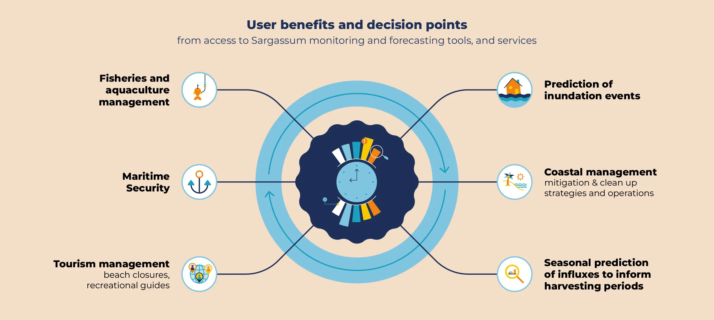
End user benefits
Gaps in monitoring and forecasting Sargassum inundations and spread
Despite all the significant progress made, there are gaps in monitoring and forecasting capacity and capabilities, which include:
Recommendations
To improve monitoring and forecasting of Sargassum, and enhance our understanding and predictions of Sargassum influxes for better evidence-based management and mitigation actions, the following recommendations are proposed:
CUEVAS, E., URIBE-MARTÍNEZ, A., et LICEAGA-CORREA, M. A satellite remote-sensing multi-index approach to discriminate pelagic Sargassum in the waters of the Yucatan Peninsula, Mexico. International Journal of Remote Sensing, 2018, vol. 39, no 11, p. 3608-3627.
DESCLOITRES, J., MINGHELLI, A., STEINMETZ, F., et al. Revisited Estimation of Moderate Resolution Sargassum Fractional Coverage Using Decametric Satellite Data (S2-MSI). Remote Sensing, 2021, vol. 13, no 24, p. 5106.
DESROCHERS, A., COX, S. A., OXENFORD, H. A., et al. Sargassum Uses Guide: A Resource for Caribbean Researchers, Entrepreneurs and Policy Makers Lead. Food and Agriculture Organization of the United Nations (FAO) Produced, 2020, no 97, p. 100.
JOHNS, E. M., LUMPKIN, R., PUTMAN, N. F., et al. The establishment of a pelagic Sargassum population in the tropical Atlantic: biological consequences of a basin-scale long distance dispersal event. Progress in Oceanography, 2020, vol. 182, p. 102269
JOUANNO, J., MOQUET, J. S., BERLINE, L., RADENAC, M. H., SANTINI, W., CHANGEUX, T., THIBAUT, T., PODLEJSKI, W., MENARD, F., MARTINEZ, J.M., AUMONT, O., SHEINBAUM J., FILIZOLA N. & N’KAYA, G. D. M. (2021). Evolution of the riverine nutrient export to the Tropical Atlantic over the last 15 years: is there a link with Sargassum proliferation? Environmental Research Letters, 16(3), 034042
JOUANNO, J., BENSHILA, R., BERLINE, L., et al. A NEMO-based model of Sargassum distribution in the tropical Atlantic: description of the model and sensitivity analysis (NEMO-Sarg1. 0). Geoscientific Model Development, 2021, vol. 14, no 6, p. 4069-4086.
MARÉCHAL, J-P., HELLIO, C., et HU, C. A simple, fast, and reliable method to predict Sargassum washing ashore in the Lesser Antilles. Remote Sensing Applications: Society and Environment, 2017, vol. 5, p. 54-63.
SOSA‐GUTIERREZ, R., JOUANNO, J., BERLINE, L., et al. Impact of tropical cyclones on pelagic Sargassum. Geophysical Research Letters, 2022, vol. 49, no 6, p. e2021GL097484.
SUTTON, M., STUM, J., et DUFAU, C. Sargassum Monitoring-Sargassum Detection in the Tropical Atlantic for Operational and Seasonal Planning. In: EGU General Assembly Conference Abstracts. 2021. p. EGU21-12695.
WANG, M., HU, C. Mapping and quantifying Sargassum distribution and coverage in the Central West Atlantic using MODIS observations. Remote sensing of environment, 2016, vol. 183, p. 350-367.
WANG, M., HU, C. Predicting Sargassum blooms in the Caribbean Sea from MODIS observations. Geophysical Research Letters, 2017, vol. 44, no 7, p. 3265-3273.WANG, Mengqiu, HU, Chuanmin, BARNES, Brian B., et al. The great Atlantic sargassum belt. Science, 2019, vol. 365, no 6448, p. 83-87.
WEBSTER, R.K., LINTON, T. Development and implementation of Sargassum early advisory system (SEAS). Shore & Beach, 2013, vol. 81, no 3, p. 1.
UNEP White Paper. 2021. Turning the crisis into an opportunity.
References
Open